


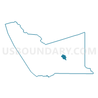
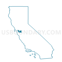
Voting District 10225, Alameda County, California
About
Outline

Summary
| Unique Area Identifier | 528646 |
| Name | Voting District 10225 |
| County | Alameda County |
| State | California |
| Area (square miles) | 4.03 |
| Land Area (square miles) | 4.03 |
| Water Area (square miles) | 0.00 |
| % of Land Area | 100.00 |
| % of Water Area | 0.00 |
| Latitude of the Internal Point | 37.61730190 |
| Longtitude of the Internal Point | -121.77159780 |
Maps

Graphs
Select a template below for downloading or customizing gragh for Voting District 10225, Alameda County, California


Neighbors
Neighoring Voting District (by Name) Neighboring Voting District on the Map
- Voting District 10110, Alameda County, CA
- Voting District 10125, Alameda County, CA
- Voting District 10145, Alameda County, CA
- Voting District 10230, Alameda County, CA
- Voting District 10345, Alameda County, CA
Top 10 Neighboring County Subdivision (by Population) Neighboring County Subdivision on the Map
Top 10 Neighboring Place (by Population) Neighboring Place on the Map
Top 10 Neighboring Unified School District (by Population) Neighboring Unified School District on the Map
- Livermore Valley Joint Unified School District, CA (84,627)
- Sunol Glen Unified School District, CA (945)